
From 'The Lenton Listener' Issue 25
July - August 1983
Lenton Rock
| Maximum Depths Of The Various Types Of Rock Under Lenton | |
| River gravels of the River Trent | 25 ft. |
| .................a large time interval........... | |
| Mapperley Plains Skerry, green-grey dolomitic siltstones | 12 ft. |
| Radcliffe Formation, mainly red marls | 80 ft. |
| Colwick Formation, mainly red sandstones and marls | 120 ft. |
| Woodthorpe Formation, buff sandstones and red marls | 40 ft. |
| Nottingham Castle Pebble Beds, buff sandstones with rounded pebbles | 200 ft. |
| Lenton Abbey Formation, fine red sandstones with thin marl seams | 90 ft. |
| ... a small time interval, 30 million years.... | |
| Middle Coal Measures ) A thick sequence Lower Coal Measures ) of siltstones, mud-stones, sandstones and thin coal seams | 2,000 ft. |
| (Continuation downwards not proved locally) | |
No, not the edible type, or the extensive cover of concrete and tarmac (artificial rock), but the natural hard stuff which persists at the surface in decreasingly few places within the Parish of Lenton. Certainly at the time James Shipman was writing on these rocks (1880's) or at the time of Walcott Gibson (1908) or even of Professor Swinnerton (1948) whom some of you may well remember, exposures of natural rocks were more numerous than today. The most obvious rock exposure this side of Nottingham is that below the Castle Museum, a buff coloured sandstone with occasional large pebbles. But the keen eye can locate others within Lenton and the small but significant differences in the rocks' appearance might suggest that the geological strata beneath Lenton are quite varied. During the construction of major buildings and roads, temporary rock exposures are frequent, showing that many of the surface rocks are sandstones of one type or another.
Building developments at the University in the 1960's and more recently at the Queen's Medical Centre have permitted the gathering of much information on these surface rocks. At the time of writing, a new underpass is being constructed at the junction of Derby Road with Middleton Boulevard and many cubic yards of red sandstone have already been removed. Even larger exposures should be visible when the main excavation commences.
Knowledge of sub-surface rocks has been gained through the quest for coal. Deep borings and extensions of coalmines have proved the existence of coal bearing strata at depth. The extraction of this coal has resulted in subsidence problems over the greater part of the area on a number of occasions, and has also proved that in the geological past, the Parish of Lenton was a much less stable area than it appears to be at the moment. The rocks present under Lenton range in age from 200 to 320 million years with a relatively recent cover of sand and gravel, the activity of the Rivers Leen and Trent.

The surface rock formations in Lenton and the surrounding area
The sequence of rock types from the youngest to the oldest is shown in the table above. Thus, details of the rocks down to about 2,500 feet are known from coal borings but considerable thicknesses of older but unidentified rock will be present below these. The layers of rock are no longer distributed evenly over the Lenton area as can be seen from the adjacent geological map. Ancient earth movements coupled with extensive erosion by rivers, the sea and by ice have resulted in a most uneven series of rock outcrops. Remember there has been plenty of time for this to happen; the scale is not of living memory or recorded history but back to a time, over 300 million years ago when the first rocks were deposited.
The prosperity of Victorian Nottingham grew on the plentiful supply of cheap coal obtained from the local collieries. The nearest ones were those of Wollaton, the Newcastle Pit (Aspley), and the Clifton Pit (Nottingham). The pits were sunk initially to extract the famous Top Hard Coal Seam, often six feet six inches thick and only a few hundred feet below the surface. After removal of this prize coal, other less thick and deeper coals were removed down to depths approaching 1,000 feet, (Tupton and associated coal). In between up to ten different seams might have been extracted, representing a total thickness of between 30 and 40 feet of coal. The result of this extractive process was man-made earth- movements - subsidence; not just a one-off effect but on a number of occasions. It is obvious that subsidence is often the culprit behind damage to property. It is less obvious that it can also increase the risk of flooding when the Trent overflows its banks. Remember the floods of the 1930's and the consequent elevation of the River Trent flood banks? The last coal workings beneath the Lenton area took place in the 1960's south of Derby Road and on the north side of the University Campus. The possibility of having to repair or replace the expensive buildings of the University made the extraction of the coal suddenly less attractive and work ceased about 1968.
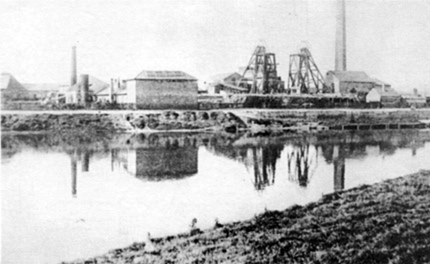
Clifton Colliery viewed from across the River Trent. Coal was discovered
here in 1867 and mining had begun by 1872. The colliery closed in 1968
and the site now houses the Queens Drive Industrial estate. Photograph
courtesy of Nottingham Local Studies Library.
The red sands referred to in the opening paragraph belong to this formation. More or less permanent rock faces can be seen on the University Campus on the north side of the Mathematics and Physics Building and the north side of the Queen's Medical Centre (see photograph below). The sand is very fine grained and close examination of the rock face will show that there are very thin (¼") marl seams present. The rocks are current bedded and were deposited in water. The chief claim to fame for these rocks is that they were used for the local moulding sands. The fine grain characteristics meant less time on finishing the cast products and the marl present in the mixture bound the grains together without recourse to further adhesives. Try pressing a handful of the loose sand in your hand; it will retain the impression of the inside of your grip. The above mentioned rock faces were old quarries and there are other examples at Bramcote, Catstone Hill (Strelley) and northwards to Mansfield where the only quarry still producing this sand still exists. The first use for this sand was for lining moulds for pig iron. The iron from, say, the Stanton-by-Dale Iron works was originally run into shallow pits, dug in the ground and lined with the sand. Eventually such pits were used only in emergencies.

The Victorian geologist, James Shipman, refers to a small sandpit
near Hillside in his Geology and the Parish of Lenton, published in
1884. Since then Thomas Suffolk and his work force removed many
thousands of tons of sand as they excavated the whole 'hillside' from
Spring Close up to the back gardens of the houses on Derby Road
and so created the rock face in the photo.
Seen to perfection in the vicinity of the Nottingham Castle Museum, the rocks are also found in many places on the north side of Canal Street and Castle Boulevard, which follow the line of the old river cliff of the Rivers Leen and Trent. There are reasonably permanent outcrops on the northwest side of the University Park Lake and elsewhere on the University Campus. The colour of the sandstone here and throughout the City is straw or buff, contrasting with the more typical red colour of the pebbly sandstones elsewhere in Nottinghamshire, for example Sherwood Forest. There is not a great deal of cohesion or cement joining the grains and the rocks are consequently extremely porous and easy to excavate - thus, the existence of the Nottingham Caves and the numerous water wells which have provided a local water supply in the past. In the immediate area, industrialisation and urban development generally, have polluted the water, but northeast of Nottingham, deep wells still supply much of the local water. There were proposals to sink new wells at the University and at Boots' Beeston site in the 1960's, but these failed either through objections or problems with the water quality.
Rocks younger than the pebble beds have a restricted distribution in the Lenton area, being found only in a narrow band extending through the University Campus across to the Priory Inn on Derby Road. The area of outcrop is bounded by two parallel lines of dislocation of the ground (faults), the younger rocks being down faulted and brought against older rocks. The high ground of the University Campus, Highfields House, the Main Library, the Social Sciences Building, and the School of Education are all situated above the Mapperley Plains Skerry (see below).
Woodthorpe Formation
The alternating buff sandstones and red marls of this group have been seen only at one location in the Lenton Parish and this was during excavations immediately to the west of Highfields House. They appear to be passage beds between the Nottingham Castle Formation and the Colwick Formations.

A modern cave 'dwelling' viewed from
Castle Boulevard.
The Colwick Formation
Best seen at Colwick Wood, to the east of Nottingham, these rocks are found at two localities within Lenton Parish. The first is close to the lake in University
Park at the northeast end and the second in a gateway on Derby Road immediately northeast of the Priory Inn. Both these exposures show weathered sandstones and marls. The surface of the marl is quite distinctive being covered by a white shiny mineral - mica (a common insulation material for electric iron elements). The mineral gives a watery sheen to the rock and explains a common term for the Formation - the Waterstones.
The Radcliffe Formation
The sandstones of the Colwick Formation eventually disappear and a marl sequence dominates. This rock is famous throughout Nottingham as a brick marl. There is some evidence that the monks at Lenton Priory used the marls for bricks and pottery and an old quarry, now holding a tennis court adjacent to Hugh Stewart Hall at the University, was excavated in these marls. The last quarry in our immediate area from which these marls were extracted was at Chilwell; the quarry has now been filled with houses! Current production of bricks from this horizon by the Nottingham Brick Company occurs at Arnold.
The Mapperley Plains Skerry
This distinctive rock is found not only at Mapperley, but also the University site and underneath the foundations of Clifton Bridge. The rock consists of a dolomitic siltstone and is extremely hard, hence its control of topography. Green-grey fragments of this rock can usually be seen in the soils derived from the rock. The rock fragments frequently possess on their surfaces small cubic shapes, ripple marks, and irregularities resulting from slight movements of the sediment prior to its hardening/slumping. The cubes are casts after the salt crystals have been dissolved (salt pseudomorphs). The ripples are current marks produced as water flowed over the soft sediment. These sedimentary structures are diagnostic of the Mapperley Plains Skerry. Unfortunately, there are left no permanent exposures of this rock on the University site. They have all been 'landscaped' and consequently destroyed.
Such are the rocks of Lenton - very interesting in themselves, as I hope you will agree. Perhaps you will be prompted to take a closer look at some of the places mentioned. These rocks also provide evidence of the past geography - the paleo-geography, extending over a period of some 100 million years and then at odd intervals to the present. But such a story will have to wait for another article.
Article written by Dr. F.M. Taylor, Geology Department, University of Nottingham